Difference between revisions of "File:Eurasia-Pacific tectonic plates.png"
From IRAIA Wiki
(A) Map showing the main plates surrounding the Philippine Archipelago. B) Major tectonic features of the Philippines. The gray shaded area is the Philippine Mobile Belt (PMB) of Gervasio (1967). The stippled gray shaded area is the Palawan-Mindoro cont...) |
|||
| Line 1: | Line 1: | ||
| − | + | Map showing the main plates surrounding the Philippine Archipelago. B) Major tectonic features of the Philippines. The gray shaded area is the Philippine Mobile Belt (PMB) of Gervasio (1967). The stippled gray shaded area is the Palawan-Mindoro continental block. AR= Abra River Fault; VA=Vigan Agao Fault; C=Cordilleran Fault; P=Pugo Fault; D=Digdig Fault; LD=Laur Dingalan Fault. (Source: New Definition of Philippine Plate Boundaries and Implications to the Philippine Mobile Belt. Lagmay, Tejada, Pena, Aurelio, Davy, David, Billedo. Journal of the Geological Society of the Philippines Vol. 64 No. 1 January-December 2009) | |
Latest revision as of 00:55, 11 May 2019
Map showing the main plates surrounding the Philippine Archipelago. B) Major tectonic features of the Philippines. The gray shaded area is the Philippine Mobile Belt (PMB) of Gervasio (1967). The stippled gray shaded area is the Palawan-Mindoro continental block. AR= Abra River Fault; VA=Vigan Agao Fault; C=Cordilleran Fault; P=Pugo Fault; D=Digdig Fault; LD=Laur Dingalan Fault. (Source: New Definition of Philippine Plate Boundaries and Implications to the Philippine Mobile Belt. Lagmay, Tejada, Pena, Aurelio, Davy, David, Billedo. Journal of the Geological Society of the Philippines Vol. 64 No. 1 January-December 2009)
File history
Click on a date/time to view the file as it appeared at that time.
| Date/Time | Thumbnail | Dimensions | User | Comment | |
|---|---|---|---|---|---|
| current | 00:55, 11 May 2019 | 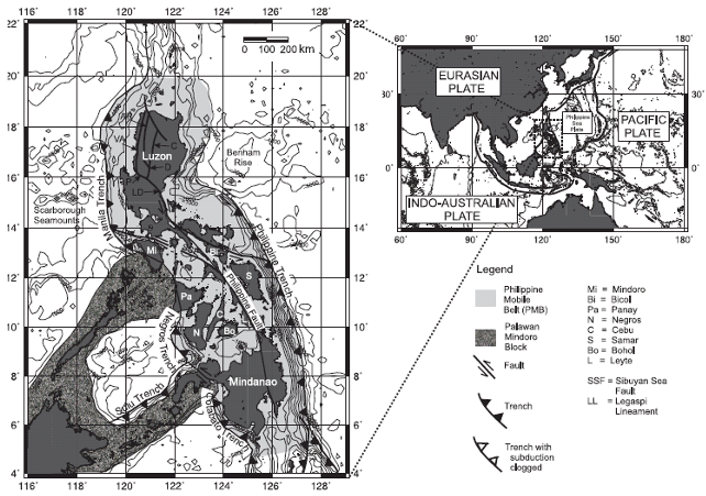 | 642 × 451 (315 KB) | Iraiawiki (talk | contribs) | A) Map showing the main plates surrounding the Philippine Archipelago. B) Major tectonic features of the Philippines. The gray shaded area is the Philippine Mobile Belt (PMB) of Gervasio (1967). The stippled gray shaded area is the Palawan-Mindoro cont... |
- You cannot overwrite this file.
File usage
The following page links to this file: